(News-Herald, August 30) One of my goals this summer was experience the full range of available bike trails in Venangoland.
Of course, I’ve trekked the civilization-heavy pedal path from Franklin to Oil City many times. More rustic is the stretch south from Franklin to the Belmar bridge. From there you can head out the Sandycreek trail, complete with several cool old railroad bridges, and a gentle uphill slope that doesn’t intimidate when you’re headed up, but provides gentle encouragement on the way back.
It’s worth crossing the Belmar bridge now because there’s another path spur from Belmar down to Fisherman’s Cove. This allows for a nice round trip bike and kayak biathlon if you’re feeling really ambitious.
But last week I finally completed the big bike aspiration I had for this summer. I pedaled all the way to Emlenton.
I’ve been tempted for a long time. When I head south, I’m always subject to Trail Suck, that powerful force that gets in your head and whispers, “Oh, just a little bit more…” and sucks you farther on down the trail. So I waited for a day when my daughter could come fetch me on the far end, and off I went.
There are plenty of great features on the Emlenton run. Of course, there’s Indian God Rock, a monument to centuries of multi-cultural graffiti. Down below Brandon, the trail stops for a bit—turn left up the hill and follow the dirt road through a village. Eventually you’ll arrive at Kent Road, which wins the award for the most generous interpretation of the word “road” ever. If your dream is to ride all the way to Emlenton without ever getting off your bike, this is where your dream dies.
But once you’re back on the trail the journey just gets better and better. There’s the Kennerdell tunnel, for which you must have some kind of light. Really. Turn off all the lights in your house at midnight, sit in the basement, put three garbage bags over your head and duct tape your eyelids shut. The Kennerdell tunnel is darker than that. It’s like riding a bicycle through the black of space; pedaling can become awkward because you lose the sense of where the ground is. My flashlight was too wimpy; don’t even ask how I carried it.
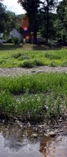
Once you emerge, there are more miles of forest and river, plenty of opportunity to enjoy being away from Stuff. In the auto age houses and stores and way stations grow up around routes, so that the road gives us continuous civilization, occasionally punctuated by bits of nature, like occasional mini-parks. But railways show a world mostly of undeveloped nature, occasionally interrupted by towns and villages. Train travel must have created a sense of small isolated outposts of humanity in a vast sea of forest, hill, and river.
The second tunnel en route is mercifully short—almost as soon as you’ve entered, a light smudge at the far end becomes comfortably visible.
Your first hint that you’ve arrived in Emlenton is a landscape of ruined foundations. As steeped in Venangoland history as I am, I am woefully undersoaked in Emlentonia; it took research to identify this as oil refinery remains. Pass a parking lot (the nicest one anywhere on the trail network) and you’re on the main drag of Emlenton.
Emlenton isn’t hard to explore, although there is directory signage that only faces one of three entryways to town, and is not really readable from a car, anyway. At one end of the town is the Emlenton Café—it smells really nice and I would have gladly eaten there, but after 27 miles on the bike trail, I was not fit to be anywhere where people were trying to eat. There are lovely riverfront views, convenience stores, and several antiquey places. Parents can shop in some cool places, but the kids can still get nachos and ice cream.
Looming up a block above the main drag is the Crawford Center, a converted school that houses municipal offices, some good historical info, a visitors’ center, a little museum that appears to be open Every So Often, plus a great old auditorium. Once again, the signage for this place is visible only on one route into town.
It’s one of the perennial indicators that Venangoland is not quite ready to be a tourist destination—we still specialize in signs that are only helpful if you already know where everything is.
My daughter and her boyfriend, an excellent navigating team as long as they have a cell phone, arrived to retrieve my rather-sweaty, semi-achy body. I should have gotten them ice cream for their trouble. It’s a fun trip; next time I’ll find a way to take along a clean shirt and a bigger flashlight.
You can find more info about the AVTA trails here


2 comments:
Pete, you wuss! No, seriously, just kidding. I was surprised to read your article while working on my own (published, finally, at http://thebikerdiaries.blogspot.com/)
I did the ride, finally, too, but I RODE THE WHOLE WAY BACK, TOO!
Which was stupid, I think, now, but I did do it.
Great article. Keep up the good work.
PS:
Sorry for all those commas. I should really learn to proof read my posts.
Post a Comment